- Rabil
- Praja
- Espargos
- Ponta do Sol
- Vila do Maio
- Plateau (Praia)
Plateau is the historic centre of the capital city of Praia on the island of Santiago, Cape Verde. It gets its name (from French “plateau”) because it is situated on a plateau overlooking the port of Praia. Its average elevation is 37 meters above sea level. The population of Pla
- Pedra de Lume
Pedra de Lume is a village in the northeastern part of the island of Sal, Cape Verde. The village is situated on the east coast, about 5 km east of the island capital Espargos. It has a small port and a lighthouse, Farol de Pedra de Lume.
- Porto Inglês
Porto Inglês (Portuguese for "English port", also: Cidade do Maio, Vila do Maio) is a city in the southwestern part of the island of Maio in southeastern Cape Verde. It is the main urban settlement of the island, and also seat of the Maio Municipality. Its population was 2,971 in
- Cruzinha
The Cruzinha Nature Reserve is a protected area in the northern part of the island of Santo Antão in the Cape Verde archipelago. It covers part of the north coast of the island, between the rivers Ribeira da Garça and the Ribeira do Mocho. It contains the only coastal dunes of Sa
- Cabo Santa Maria (ship)
Cabo Santa Maria (Spanish: Cabo Santa María) was a Spanish general cargo ship built by Empresa Nacional Bazán at Cartagena, Spain. She was one of four Type Y merchant ships ordered under the new-construction programme of the state-owned Empresa Nacional Elcano. Launched on 20 Dec
- Museu Etnográfico da Praia
Museu Etnográfico da Praia is an ethnographic museum in the Cape Verdean capital of Praia on the island of Santiago. It is located at 45 Rua 5 de Julho, in the historic part of the city, the Plateau. The museum was opened in November 1997 and is located in a 19th-century building
- Ilhéu Rabo de Junco
Ilhéu Rabo de Junco is an uninhabited islet near the west coast of Sal Island, Cape Verde. It lies about 300 metres (980 feet) from the coast. It is 253 metres (830 feet) long and 165 metres (541 feet) wide, its shoreline is about 878 metres (2,881 feet) long. It is the only isle
- Forte de São José (Maio)
Forte de São José (Portuguese for the Fort of Saint Joseph) is a fort located in the city of Porto Inglês in the southern part of Maio Island, Cape Verde. It was built by the Portuguese around 1743, in order to protect the town of Porto Inglês from pirate attacks. Today, the fort
- Fontainhas
Fontainhas is a settlement in the northern part of the island of Santo Antão, Cape Verde. It is situated near the rocky north coast of the island, two km southwest of Ponta do Sol and 19 km north of the island capital Porto Novo. The settlement includes the smaller villages Corvo
- Ilhéu de Sal Rei
Ilhéu de Sal Rei is an uninhabited islet near the coast of Boa Vista Island, Cape Verde. It is located 1 km (0.6 miles) southwest of the island capital Sal Rei. Its area is 89 ha (0.34 sq mi) and its highest point is 27 m (88.6 ft). The islet has exposed basaltic and limestone ro
- Quartel Jaime Mota
Quartel Jaime Mota is a historical building in the historic city centre (Plateau) of Praia, Cape Verde. It is situated at the southern end of Avenida Andrade Corvo, near the Presidential Palace of Cape Verde. It was built between 1823 and 1826 as a military barracks. The present
- Rabo de Junco
Rabo de Junco (also: Monte Leão) is a hill on the west coast of the island of Sal in Cape Verde. It is situated at the northern end of the Baía da Murdeira, 8 kilometres (5.0 mi) southwest of the island capital Espargos. Its steep eroded south face towards the bay is an important
- Maio, Cape Verde
Maio (Portuguese for "May"), is the easternmost of the Sotavento islands of Cape Verde. Maio is located south of the island of Boa Vista and east of Santiago. Administratively, the island forms one concelho (municipality): Maio.
- Nossa Senhora do Livramento, Cape Verde
Nossa Senhora do Livramento is a freguesia (civil parish) of Cape Verde. It covers the northern part of the municipality of Ribeira Grande, on the island of Santo Antão.
- Morro de Areia Nature Reserve
Morro de Areia Nature Reserve (Portuguese: Reserva Natural do Morro de Areia) is a nature reserve covering the southwestern coast of the island of Boa Vista in Cape Verde. It takes its name from the hill Morro de Areia, 167 m (548 ft) elevation. The natural reserve covers 21.31 k
- Chã de Areia
Chã de Areia is a subdivision of the city of Praia in the island of Santiago, Cape Verde. Its population was 247 at the 2010 census. It is situated south and west of the city centre. Adjacent neighbourhoods include Plateau to the northeast, Achadinha to the north, Várzea to the w
- Baía da Murdeira
Baía da Murdeira is a wide crescent shaped bay on the southwest coast of the island of Sal in Cape Verde. It takes its name from the village Murdeira, which lies at its shore. At its northwestern end lie the steep cliff of Rabo de Junco and the islet Ilhéu Rabo de Junco. The bay
- Ribeira Dom João
Ribeira Dom João is a settlement in the southeast of the island of Maio in Cape Verde. It lies near the coast, 4 km east of Barreiro and 10 km east of Porto Inglês. As of the 2010 census, its population was 203.
- Lagoa do Rabil
The Lagoa do Rabil (Rabil lagoon) is a wetland site in the Cape Verde archipelago, on the island of Boa Vista. It has been recognised as a wetland of international importance by designation under the Ramsar Convention since 2005. The site lies at the mouth of the seasonally flowi
- Pro-Cathedral of Our Lady of Grace, Praia
The Pro-Cathedral of Our Lady of Grace (Portuguese: Pró-catedral Nossa Senhora da Graça) is a catholic church on the east side of Praça Alexandre Albuquerque, in the city centre of Praia, on the island of Santiago, Cape Verde. The church was built between 1894 and 1902. It is the
- Monte Grande (Sal)
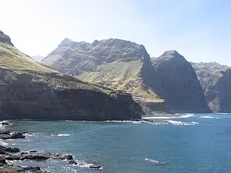
Monte Grande (Portuguese meaning “big mountain”) is a mountain in the northern part of the island of Sal in Cape Verde. It is situated 8 km northeast of the island capital Espargos. At 405 m (1,329 ft) elevation, it is the highest point of the island. It is a protected landscape
- Monte Batalha
Monte Batalha is a mountain in the island of Maio in Cape Verde. Its elevation is 294 m. It is situated 4 km southeast of Calheta and 8 km northeast of the island capital Porto Inglês.
- Forte Duque de Bragança
Forte Duque de Bragança is a ruined fort located on the islet Ilhéu de Sal Rei off the northwestern coast of the island of Boa Vista, Cape Verde. The fort was named after the Duke of Bragança. The fort overlooks a stretch of coast where the anchorage required defending from pirac
- Monumento de Diogo Gomes
The Monumento de Diogo Gomes is a statue at the south end of the Plateau, the historic centre of Praia, on the island of Santiago, Cape Verde. It represents Diogo Gomes, the Portuguese navigator who was one of the discoverers of the island of Santiago in 1460. The cast iron statu
Muzeji, verski i istorijski objekti, priroda — sa fotografijama, opisom i uputstvom




Nastavkom korišćenja Platforme prihvatate cookies i slične tehnologije. Ako se ne slažete, prekinite korišćenje.
VIDI politika privatnosti
·
VIDI politika kolačića
Nastavkom korišćenja Platforme prihvatate cookies i slične tehnologije. Ako se ne slažete, prekinite korišćenje.
VIDI politika privatnosti
·
VIDI politika kolačića